The Top 10 Canadian Rocky Treks
It has been rightly said that the Canadian Rocky Mountain will offer you so many opportunities to explore, that you simply cannot exhaust them in one lifetime. However, as a tourist, it can get quite overwhelming to choose which trail you want to hike from hundreds of options, or which ones suit well to your skill levels or itinerary. We have listed out the top 10 Rocky Mountain hikes to help you choose.
By Online Canada Visa
If you are someone who enjoys challenging but rewarding hikes with otherworldly views, then the Rocky Mountains in Canada is just the place for you to be! Whether you are hiking at the Jasper National Park, Banff National Park, or the Yoho National Park, or simply taking a walk down the trails that lay outside these spectacular destinations - you are going to be stunned by the variety of marvelous sceneries, diverse wildlife, and fun adventure that this place has to offer to you!
If you are looking for a shift from the city vacations with its high-end resorts and booze cruises, then adventuring through the picturesque green outdoors in the Canadian Rockies might be the opportunity for you. Whether you are more inclined to hike through crazy mountains or love to click pictures of breathtaking heights, the Canadian Rockies is the place to be! Be ready to hike through hundreds of kilometers of majestic scenarios seated in the lap of grand nature, without ever getting bored.
The Alpine Loop (Lake O’Hara)
Although not a simple walk in the park, the Alpine Loop situated at Lake O’Hara is a trail that leaves its visitors exhausted but satisfied with its astounding beauty. In this hike, you will have to climb 490 meters, through a series of steep curves.
As the name suggests, the hiking trail is a loop that can be covered from either direction. However, it is recommended to go clockwise, since it will allow you to cover most of the steep climbing right at the beginning of the hike.
Being one of the most beautiful lakes in Western Canada, once you reach Lake O’Hara, you will quickly understand why it rightly deserves all that fame! The site will offer you several side trails through which you can change your route and enjoy different scenarios, as you make your way through the loop.
All the trails are clearly marked for the convenience of the visitors, but make sure that you do not miss out on the mesmerizing Lake Oesa and the equally stunning Lake Hungabee.
- Where is it located - Yoho National Park
- Distance - 10.6 km for a round-trip
- Elevation gain - 886 meters
- Time required to trek - 4 to 6 hours
- Difficulty Level - moderate
Tent Ridge Horseshoe
Although quite a challenging hike, the Tent Ridge Trail makes all your effort worth it with its picturesque vista. The hike starts off from the heart of a beautiful forest, and you can enjoy it’s refreshing views for the next 45 minutes. Just as you come out of the forest and the best part of the hike begins, you will have to face an abrupt and steep trail that will take you up to some rubble and scree.
The path is narrow and quite close to the edge of the cliff, making this section rather nerve-wracking for hikers. If you have a fear of heights, then this hike is not for you! The trail that will lead you to the highest peak of the Tent Ridge Horseshoe is steep and follows closely to the ridge.
However, when you are at this height, no matter which way you look, you will be greeted by a magnificent view. While you are making sure that you stay on the marked trail, do not forget to look back often at the bewitching scenario around, and enjoy your hike! The incredible view will make you forget all your exhaustion!
- Where is it located - Kananaskis Country
- Distance - 10.9 km for a round-trip
- Elevation gain - 852 meters
- Time required to trek - 4 to 6 hours
- Difficulty Level - Difficult
Piper Pass
 Piper Pass
One of the favorite trekking trails for adventure lovers, one of the greatest benefits that the Piper Pass offers is that you can opt to shorten or lengthen your hike according to your time and fitness level. The pass will present you with plenty of nice stops in the course that will make for a short, but memorable adventure.
The trek is usually not crowded with tourists, so you can expect to have a peaceful hike to rejuvenate your mind. If you are lucky, you might even encounter wildlife on your way! The first stop in the journey will be the Elbow Lake, whose crystal clear waters will offer you a stunning reflection of the surrounding mountain range.
Once you have crossed the Elbow River, you will be greeted by the stunning Edworthy Falls. Make sure that you carry a pair of good water shoes and bags since you will have to follow the Edworthy Falls until you reach a forest path, which will lead you to the Piper Creek and Elbow River.
If you keep climbing through the green forests, you will reach a majestic alpine meadow. Next, you are free to decide whether you want to cover the last 250 meters, which goes up at a steep elevation gain of 100 meters. However, if you successfully reach the top, you are going to be rewarded with a majestic view!
- Where is it located - Kananaskis Country
- Distance - 22.3 km for a round-trip
- Elevation gain - 978 meters
- Time required to trek - 7 to 9 hours
- Difficulty Level - Difficult
Pocaterra Ridge
 Pocaterra Ridge
A rewarding one-day hike that can be covered in either direction, the Pocaterra Ridge is best started at Highwood Pass parking lot and finished at Little Highwood Pass. Although you will be required to arrange a vehicle that will drive you up to the parking lot, taking this route will save you from covering a steep elevation gain of 280 meters, so it is well worth it!
The trail with its pretty green surroundings takes up a majority of the hike, but you will be greeted by a few wooded sections in between that usually remain muddy throughout the year. So it is recommended to keep this in mind while you choose your attire for the day.
Just as the name suggests, to reach the Pocaterra Ridge trail, you will first have to go through a mountain ridge. You will have to climb four summits along the ridge, but the good news is that the first one is by far the hardest. A few parts of the trail might get steep and rough, so some people prefer to cover it using hiking poles. We advise you to hike this trail during fall, the colors will leave you simply awestruck!
- Where is it located - Kananaskis Country
- Distance - 12 km for a round-trip
- Elevation gain - 985 meters
- Time required to trek - 5 to 7 hours
- Difficulty Level - Difficult
Plain of Six Glaciers Teahouse
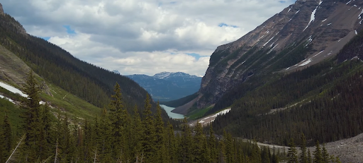 Plain of Six Glaciers Teahouse
When you visit Lake Louise, be ready to be met with more than one tea house! While the Lake Agnes Teahouse is a more popular one in the region, the Plain of Six Glaciers trail has its own little yet elegant tea house. However, it usually does not remain as crowded as the former, thus offering you an amicable and tasteful experience.
In order to reach the Plain of Six Glaciers Teahouse, you will first pass by the stunning Mount Lefroy, Mount Victoria, and Victoria glaciers. Not only will you be mesmerized by the exceptional views, but you will also get a chance to get a glimpse of diverse wildlife, including mountain goats, chipmunks, and Grizzly Bears. You will also not be let down by the flavorful hot cup of tea!
While the first half of the trail is quite straightforward following the Lake Louise shores, the second half sees a steep elevation gain of almost 400 meters passing through different terrains. It is the last few switchbacks that might get a little difficult, but the reward is worth the effort!
- Where is it located - Lake Louise
- Distance - 13.8 km for a round-trip
- Elevation gain - 588 meters
- Time required to trek - 5 to 7 hours
- Difficulty Level - Moderate
Johnston Canyon
 Johnston Canyon
A must-visit if you are going to the Canadian Rockies, it is a rather easy hike that is suitable for children as well. You will be given several options to cover the 1.2 km of the Lower Falls trail. The next part of the hike, the less crowded Upper Falls will need some backtracking and going up a trail of stairs.
Since the first 1.3 km of the trail goes through a forest, most visitors turn their back by this point. However, we suggest you hold on and keep going to the Ink Pots that are located 3 km further on. This part of the hike may be a bit challenging, but the multiple pools of colored mineral springs that bubble in a bright meadow are going to leave you fulfilled and happy.
- Where is it located - Banff
- Distance - 5 km for a round-trip; 11 km if you go to the Ink Pots
- Elevation gain - 120 meters; 330 m with the Ink Pots included
- Time required to trek - 2 hours; 4.5 hours with the Ink pots included
- Difficulty Level - Easy
Smutwood Peak
 Smutwood Peak
Climbing up the Smutwood mountain is an experience of a great adventure. You will not forget about this one-day hike anytime soon with its spectacular journey. First, you will need to pass through a little patch of scrub, which will take you to the steep elevation of Smuts Pass.
Slowly hiking through the pass, you will be greeted by the spectacular scenery of Lower Birdwood Lake and Commonwealth Creek Valley. The hike will continue at a slow pace until you reach the last 100 meters. Since the hiking trail is not very clearly marked, we advise you to pay close attention to your steps.
Once you have reached the summit, you are going to be amazed by the stunning view. The rugged Mount Birdwood in the south, a tranquil alpine terrain, the glistening glaciers of Mount Sir Douglas, the emerald blue waters of Birdwood, the crystal clear Spray River Valley in the west, the impressive Mount Assiniboine in the northwest, and other towering peaks - there is simply no end to the wonders that this hike has to offer.
- Where is it located - Kananaskis Country
- Distance - 17.9 km for a round-trip
- Elevation gain - 782 meters
- Time required to trek - 7 to 9 hours
- Difficulty Level - Moderate
Sulfur Skyline
 Sulfur Skyline
The clearly marked Sulfur Skyline is a relatively steady climb to the very peak. With only one stop in between, here you will be required to take a right turn. Finally, you will appear above a tree line, from where you will be able to observe the dome at a distance. It is this last part that leads up to the summit that is the most challenging.
When you finally reach the top, all your efforts will be paid off with a grand view of countless valleys and mountains, enveloped by a picturesque river. The most spectacular views are that of the Utopia Mountain on the southern side, Mount O’Hagan on the southwest, and the scenic Slide Mountain in the southeast.
However, keep in mind that you will be met with strong winds at the peak, so it is advised to carry warm clothes and a windbreaker when you take this hike. Once you have completed the hike, make sure that you enjoy a refreshing dip at the nearby Miette Hot Springs.
- Where is it located - Jasper
- Distance - 7.7 km for a round-trip
- Elevation gain - 649 meters
- Time required to trek - 3 to 5 hours
- Difficulty Level - Moderate
Peyto Lake
 Peyto Lake
We have some good news - to enjoy a beautiful hiking experience, you do not have to hike through a difficult trail, and the Peyto Lake trail is the leading example of that. One of the highlights of the trail is the Banff National Park, the iconic Peyto Lake is suitable for an easy day out with your family.
This short tour is guaranteed to excite you with its stunning scenery. This extremely popular hiking trail is a favorite of tourists, and you are most likely to be greeted by a crowd of equally enthusiastic hikers. However, if you are someone who likes to enjoy their hike in peace, we recommend you to go there in the early morning.
- Where is it located - Banff National Park
- Distance - 2.7 km for a round-trip
- Elevation gain - 115 meters
- Time required to trek - 2.5 hours
- Difficulty Level - Easy
READ MORE:
Travel Guide to Banff National Park
Indian Ridge
 Indian Ridge
Starting from the Jasper SkyTram, the Indian Ridge hike climbs past the Whistlers Mountain. While the first section of the trail tends to be quite crowded, as you continue down the trail it will eventually get quieter. The trail to Whistler's Peak stretches for 1.2 km, and visitors usually go down after reaching the peak. However, if you love to hike and enjoy gorgeous scenarios, we recommend you to take the full trip to the Indian Ridge.
Once you have reached the base of the ridge, the path will get very steep with a scree slope, so make sure that you watch your steps! On the way, you will be passing over five humps, and it keeps getting progressively steeper and more challenging with each one.
The last one is the Indian Summit, which most hikers do not make it up to. However, if you can make it that far, you are going to be stunned by the mesmerizing views.
- Where is it located - Jasper
- Distance - 8.8 km for a round-trip
- Elevation gain - 750 meters
- Time required to trek - 3 to 5 hours
- Difficulty Level - Moderate
Hiking is an activity that lies close to the heart of most travelers. With a recent shift of traveler’s interests from luxury holidays to outdoor activities in the past few years, the realization that we are a part of something bigger is getting more profound in us.
If you want to feel like you are one with mother nature, or simply want to appreciate the beautiful sceneries that surround us, the Canadian Rockies are the place to be. So why wait anymore, wake up your inner wanderlust, and pack your bags - it is about time that you take a break and rejuvenate your senses with a hike to the mesmerizing Canadian Rocky Mountains.
READ MORE:
The first national park of Canada. The national park with its humble beginning starting as a 26 square km hot spring to now the sprawling 6,641 square kilometers it covers. Learn about Travel Guide to Banff National Park.
Check your eligibility for eTA Canada Visa and apply for eTA Canada Visa 72 hours in advance of your flight. British citizens, Italian citizens, Spanish citizens, French citizens, Israeli citizens, South Korean citizens, Portuguese citizens, and Chilean citizens can apply online for eTA Canada Visa.
